Developing an indoor navigation system involves merging advanced technology with a user-focused design.
This guide presents a strategic approach to creating high-precision and user-friendly indoor navigation solutions for malls, airports, and offices.
We cover key steps and technologies to develop a reliable and intuitive indoor navigation system.
1
General Approach to App Development with Indoor Maps
An indoor map development project goes through the following phases:

- Analysis. Collecting requirements, analyzing business needs, and transforming them into technical requirements.
- Planning. Determining the scope of work for the upcoming development phase, specifically focusing on integrating indoor maps.
- Development. Implementing requirements into the real product.
- Validation. Ensuring that all developed functionalities, especially those related to indoor maps, meet the requirements.
In the case of a fixed-price project, these phases may extend throughout the entire project timeline. A sprint, which is a short, time-boxed period during which a specific set of tasks is completed, can be used to manage these phases effectively. Each sprint can be completed using an Agile development approach.
2
How Do Indoor Navigation Apps Work?
Indoor navigation apps use various technologies to help users navigate complex indoor spaces where GPS signals are often unreliable or unavailable. Here are the main technologies used:
- BLE Beacons: A set of BLE beacons installed in a venue along with a configured map provide positioning accuracy within 2 to 3 meters and allow for user positioning and asset tracking with additional equipment.
- Wi-Fi: A Wi-Fi router installed in a venue along with a configured map offer positioning accuracy within 3 to 15 meters. This technology also supports user positioning and asset tracking with additional equipment.
- Ultra-wideband: These receivers installed in a venue along with a configured map offer extremely high positioning accuracy down to 0.1 meter. Ultra-wideband technology supports user positioning and asset tracking with additional equipment.
- Geomagnetic: A few BLE beacons installed on each floor along with a configured map provide positioning accuracy between 2 to 3 meters. This allows for user positioning but does not support asset tracking.
3
Market Insights
The indoor navigation market is rapidly evolving, shaped by technological advancements and emerging user needs.
Here are key insights and statistics that underscore the current landscape and the future potential of indoor maps and navigation.
Technological Advancements Fueling Innovation:
- Integrating IoT, AI, and sensor technologies pushes the boundaries of what’s possible, offering seamless indoor–outdoor navigation experiences.
- Bluetooth 5.1 and newer Wi-Fi standards enable more precise location tracking within indoor environments.
Market Growth Projections:
- North America and Europe constitute the largest markets for indoor positioning and navigation systems, making up the majority of global market share. Specifically, the United States comprises approximately 40% of the worldwide market.
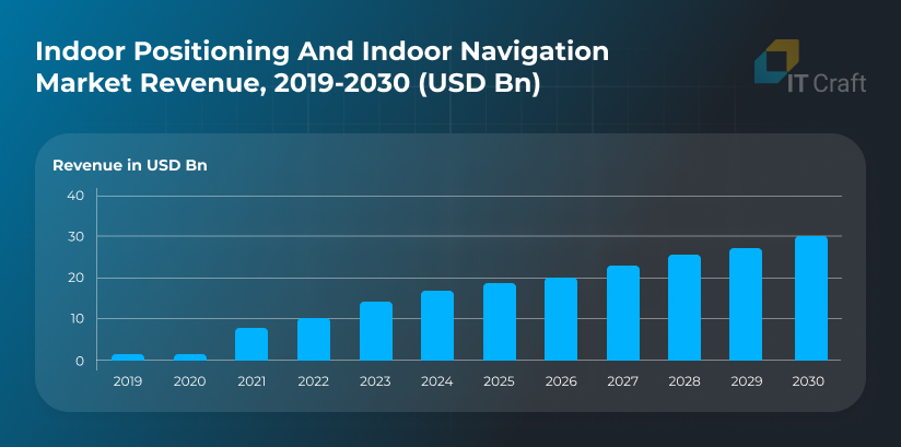
- The global market for indoor navigation is anticipated to reach USD 30.20 billion by 2030, with expansion largely fueled by the rising demand for proximity marketing, augmented reality (AR), and location-based analytics.
These technologies enable businesses to offer tailored experiences, boost the impact of advertising, and increase operational efficiencies.

Source: Global indoor positioning and indoor navigation market size
4
Key Functions of Indoor Navigation Applications
Indoor navigation applications serve as digital compasses, guiding users through complex indoor spaces such as malls, airports, hospitals, and corporate campuses.
Here are some of the core features that define these innovative solutions:

- Real-time Positioning and Wayfinding: This feature accurately pinpoints a user’s location and guides the user with step-by-step directions. It typically uses Wi-Fi, Bluetooth beacons, and occasionally augmented reality (AR) for an enhanced navigation experience.
- Interactive Maps: Detailed, interactive indoor maps that offer zoom, search, and filter capabilities are essential. They allow users to view the layout of a premises, including points of interest such as exits, restrooms, conference rooms, and dining areas.
- Location-based Notifications: Applications can send notifications and alerts based on a user’s location within a facility. This feature is particularly useful for promotions in retail environments, safety alerts in industrial settings, or reminders in office buildings.
- Accessibility Options: Indoor navigation solutions can provide routes that cater to the needs of all users, including those with disabilities, ensuring an inclusive navigation experience. Routes might avoid stairs or offer the shortest path to elevators.
- Indoor Positioning System (IPS): This type of system uses various technologies to facilitate the indoor positioning of users, which is crucial for delivering accurate navigation and wayfinding solutions within complex indoor environments.
- User Analytics: This feature collects data on user movements and behaviors within the space, offering valuable insights for businesses and facility managers to improve layout design, operational efficiency, and the user experience.
- Multi-platform Support: This ensures that the application is accessible across various devices and operating systems, including smartphones, tablets, and wearables, enhancing usability.
- Integration Capabilities: The ability to integrate with other systems and applications, such as event management systems in conference centers or inventory management systems in retail stores, enhances the app’s overall utility and indoor map quality.
ENHANCE NAVIGATION WITHIN YOUR SPACE
Leverage our indoor navigation solutions to streamline the wayfinding experience. Elevate your facility’s navigability with our cutting-edge apps.
Explore Navigation Solutions
5
Advantages for Businesses
Implementing indoor navigation systems offers many benefits for businesses across various sectors, enhancing operational efficiency, customer satisfaction, and user engagement. Here are some of the key advantages companies stand to gain:

- Enhanced Customer Experience: Real-time indoor navigation with indoor maps improves the overall customer experience by enabling easy location of products, services, and facilities within large complexes, reducing frustration and saving time.
- Increased Engagement and Sales: Location-based notifications and offers can drive higher engagement and sales by delivering targeted promotions and information to customers based on their precise location within a facility.
- Operational Efficiency: Insights gathered from user movement and behavior analytics can help businesses optimize layout designs, effectively manage foot traffic, and improve staffing and security measures.
- Asset Tracking: Systems can facilitate efficient asset tracking and management for businesses with lots of equipment, reducing losses and improving asset use.
- Safety and Emergency Management: In emergencies, indoor navigation apps can guide occupants to the nearest exits safely and efficiently. They can also provide emergency responders with critical information about a facility’s layout.
- Data-Driven Decision-Making: The rich data collected through indoor navigation apps offers valuable insights into customer preferences, peak traffic times, and movement patterns, enabling informed decisions to enhance services and operations.
6
Specifics of Indoor Navigation Projects
When developing an indoor navigation app, a big part of the functionality is connected to the navigation provider. The map should be configured on the vendor’s side and then integrated into the application.
In general, the flow for creating an indoor navigation application will be:

Let’s go through each step.
Define the business need
Each project starts with a business need that must be resolved. The key to success is establishing the project goal and understanding the target audience and their needs.
Gather requirements
The next step after determining business needs is transforming them into technical requirements. Usually, this step involves a business analyst (BA). The BA creates the project’s main documents, such as the roadmap and the SRS. In this step, requirements can be gathered for the whole project or a small part.
Select the map provider
Based on the project’s requirements and the desired result, the BA and the technical team will choose the optimal approach and SDK for positioning and navigation, considering factors like subscription costs, equipment prices, venue size, and floor count. This decision is crucial, as the selected SDK will form the project’s core.
Configure the map
This step is connected to map configuration on the indoor navigation provider’s side. These are the usual steps:
- Create an account on the provider’s site
- Upload a map of the indoor space that you wish to navigate
- Install a mobile application developed by the navigation provider
- Take measurements on-site using that app — walk through the venue with the app running so the provider can collect data and do fingerprinting
These steps may vary for different providers. For example, these are the steps for Apple Indoor Navigation:
- The owner of the building (who must have a registered company) fills out the form you can find on this website.
- Apple validates the information and approves the registration.
- A building plan is created, or an existing plan is converted from another format to Indoor Mapping Data Format (IMDF).
- The IMDF archive should be uploaded and validated in two scenarios: when navigation within it is desired, or when it involves an airport that needs to be published in the Apple Maps application. For instance, the World Health Organization completed this process for the Berlin Airport, which is now accessible on Apple Maps with indoor navigation capabilities.
- If you wish to enable navigation within a private building, such as a factory, mall, or hospital, you need to first download and validate the IMDF. Following that, you must accurately position and bind the building’s internal layout using the Indoor Survey program.
Some map providers skip the fingerprinting step, as they provide self-learning indoor maps. Additional on-site configuration may be optional.
Embed the map in the application
After creating the map on the provider’s side, it is time to integrate it into your application. This step depends on the selected provider. Some providers only offer a map background image and another 2D or 3D map. Both of these options should be considered to achieve the best results for the application.
Add business logic to the map
Here is where all the interesting things start. Navigation SDKs are great technologies, but they remain instruments for businesses. A navigation SDK itself is not an answer to business needs. Additional logic on top of it is that answer.
For example, navigation can be used in different domains: retail, healthcare, airports, etc. All of these domains have different needs, and usually, these needs won’t be covered only by navigation. Functionality such as search, advertisements, and saving locations give value to the user and can be developed on top of navigation functionality.
Publish the app
The final step is releasing the application — first for beta testers, then publicly for all users.
OPTIMIZE YOUR INDOOR SPACES
Unlock advanced indoor navigation projects tailored to your venue. Drive efficiency and user satisfaction today.
Discover Our Services
7
How Much Does It Cost to Develop an Indoor Navigation Product?
The cost of creating an indoor navigation product can differ greatly depending on factors such as the solution’s complexity, the technologies employed, the scope of deployment, and the location of the development team.
Here’s a breakdown of the potential costs:
- Initial Planning and Conceptualization: Depending on the project’s scope, this phase can cost anywhere from $5,000 to $20,000. It requires researching the market, defining the project’s goals, and designing initial concepts.
- Software Development: The bulk of the expense comes from software development, which includes app design, coding, integration of positioning technologies (such as BLE beacons or Wi-Fi), and back-end server infrastructure. Development costs for a basic indoor navigation app may range from $50,000 to $150,000.
More complex applications with advanced features such as AR navigation, real-time analytics, or integration with existing systems could push costs upwards of $200,000 to $500,000. - Hardware Components: If the solution requires installation of hardware like BLE beacons, the costs can range from $10 to $30 per beacon, with a large facility potentially needing hundreds to ensure accurate positioning. This can add $10,000 to $30,000 or more to the total cost, depending on the size of the area covered.
- Maintenance and Updates: Ongoing costs for app maintenance, updates, and server hosting typically range from 15% to 20% of the initial development cost annually. A $100,000 project means $15,000 to $20,000 in yearly maintenance fees.
- Marketing and Launch: Costs for marketing the app to end-users or businesses can vary widely, but expect to allocate at least $10,000 to $50,000 for initial marketing efforts to ensure your product reaches your target audience.
8
Essential Technologies for Indoor Navigation Apps

Proximity-Based Positioning
This technology detects the proximity between a receiver, like a smartphone, and a transmitting device, like a Wi-Fi router. It measures how close the devices are to each other to estimate the user’s location.
Trilateration Techniques
Trilateration calculates an object’s position by measuring its distance from multiple known points (typically radio wave sources). The strength of the signal indicates how far away the object is from these points.
Signal Fingerprinting
Fingerprinting uses the intensity of signals captured over time to pinpoint a device’s location. This data, consisting of signal strengths and coordinates, is stored in a database to match and locate new devices when they appear on the network.
Motion-Based Positioning
This method uses a smartphone’s built-in sensors, such as accelerometers, gyroscopes, and magnetometers, to track the device’s movements and, consequently, the user’s trajectory within an indoor space.
Bluetooth and Wi-Fi Networks
Indoor positioning systems often rely on Bluetooth and Wi-Fi because they can operate effectively where GPS signals are obstructed, such as inside buildings.
Near-Field Communication (NFC)
NFC tags can be placed around a facility, and smartphones can update their position in real time as they come into proximity with these tags.
These technologies allow for aggregating the data necessary to create precise indoor maps. Such maps are crucial for providing accurate location information, thereby enhancing users’ navigational experiences.
9
IT Craft’s Pioneering Role in Advancing Indoor Navigation
Smart Navigation Systems
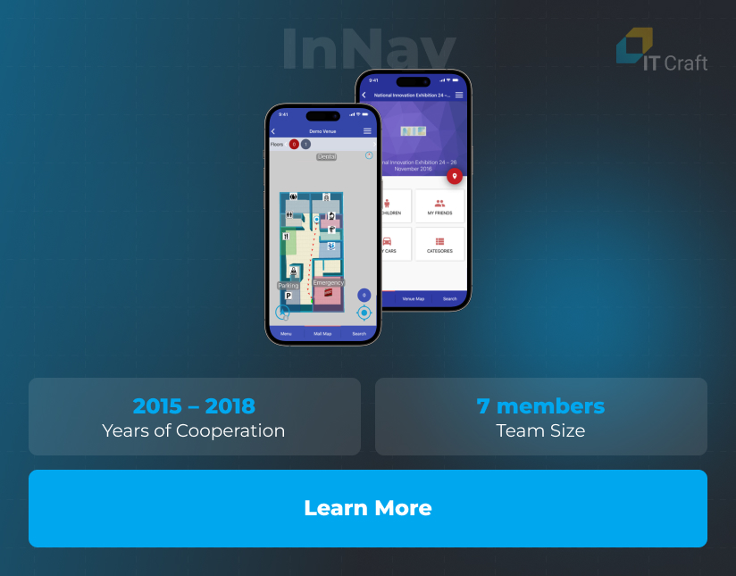
IT Craft has been instrumental in transforming the indoor navigation experience through its work with Smart Navigation Systems, a visionary startup from the UAE dedicated to improving indoor positioning. A tailored team of seven specialists from IT Craft has contributed to this success.
Our joint effort has yielded a sophisticated indoor tracking and marketing platform, enabling visitors to navigate expansive venues with intuitive turn-by-turn instructions and notifications via BLE beacons.
Key Achievements & Contributions:
- Developed bespoke iOS and Android apps for user navigation and a web admin panel for streamlined system control.
- Expanded the system’s application across various facilities, encompassing retail locations and corporate environments.
Strategic Technological Enhancements:
- Innovated with user-centric features such as Find-my-car for easy parking location recall and Outdoor-to-indoor navigation for seamless transition guidance.
- Implemented a white-label model, allowing businesses to customize and brand the navigation system for their premises.
Recognition & Broader Implementation:
- The system’s adaptability and forward-thinking design have set new benchmarks for indoor navigation systems, offering versatile and tailorable solutions for various venues.

!
Conclusion
Developing an indoor navigation system requires strategic planning, knowledge of advanced technologies, and a focus on user needs. This approach offers a roadmap for businesses to enhance the user experience and improve operational efficiency across various settings, from retail locations to airport terminals.
As technology advances, indoor navigation systems will become more precise and interactive, transforming how users interact with indoor spaces and creating smarter, more connected environments.


