Indoor Location Tracking
Optimize facility usage with a custom indoor location tracking and navigation system.
Navigate through the shortest route, locate equipment, tap into visitors’ habits, or send emergency notifications.
Isn’t it time to raise the effectiveness of your business?
How Do Indoor Positioning Systems Work?
Indoor location tracking helps in many cases. It is required to create routes, navigate users, locate items and inventory assets, and more.
What is a powerful solution for indoor positioning?
A system that combines a number of technologies that can serve as “indoor GPS tracking”, including geomagnetic map, BLE beacons, and motion sensors.
Collected data is merged for navigation accuracy of approx. 2 ft. – 6 ft. (0.5 m to 2 m) possible.
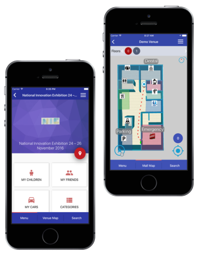
Indoor Location & Navigation Services and Capabilities
Streamline your marketing, sales, and support. Employ ChatGPT development services to craft personalized marketing campaigns that resonate with individual customer preferences.
Help sales managers identify qualified leads and modify offers to meet their exact needs. Introduce an AI assistant to let customers find an answer to frequent questions, saving your support team from burnout.
Here is how we can help you:

Real-Time Indoor
Positioning
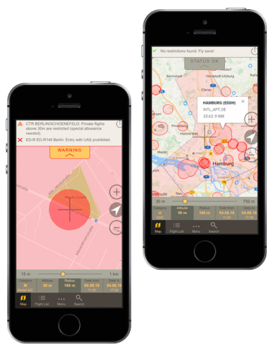
Real-time navigation apps help manage busy venues, guiding users to a selected destination point. IT Craft integrates indoor location services of several types, ensuring accurate positioning inside all venue types.

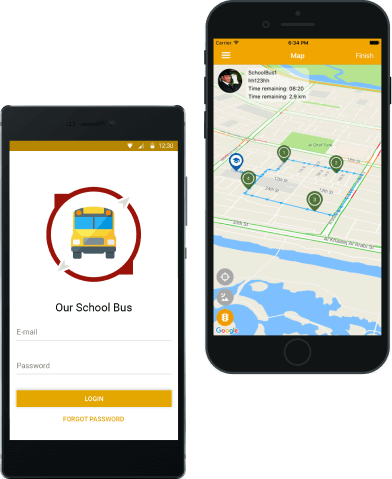
GPS and Navigation Applications
Optimize routing with a custom mapping app. Add required layers and points automatically. Track users with the help of GPS, Wi-Fi, or 4G LTE networks. Our team delivers a stand-alone app exchanging data with external software.

Point-of-Interest
Locating
Help users organize an adventure tour across the city. Provide instructions for reaching destination points. Activate interesting visual and audio content. We build a system and help you update it regularly, ensuring user engagement.

Geo App
Development
Successful apps often depend on correct indoor location tracking: it boosts transparency and, thus, customer loyalty. We adjust your app to your specific idea, encouraging your users to remain loyal.

Integrations and Customizations
Custom solutions create the most value; they are the best fit when you need technical excellence. Our team provides necessary improvements by integrating technologies for precise “GPS location tracking” or introducing custom algorithms.

Geofencing and Location-Based Services
Geofencing technologies help determine user proximity and trigger an event based on that. Safety increases. Context-based promotional campaigns also become possible. We help you build geofences, set up triggers, and detect user activities.
Which indoor mapping technology is best for you?
Contact us. Let's determine the best implementation for you together.
Contact us


Our cases
Our clients' success stories.
We love to hear what they say about us.
Stories of people impressed by our service offerings
Our Process
Here is how we turn your idea into a tight-knit indoor navigation system:
Do you want to ensure precise indoor location tracking?
Let’s start working on an effective implementation today.
Contact us
Why Choose IT Craft for Indoor Navigation Development?
By building indoor navigation software at IT Craft, you can count on:
Value-focused solutions
Our engineers prioritize functionality that generates the most business value. If your requirements change, we adjust priorities.
Full-cycle services
You find all technical services needed to move your project from a concept to a fully featured system.
Data security
The team implements data protection policies and high-security standards to ensure your indoor location services are safe.
Transparent communication
You get regular reports and test deliverables after each sprint. You participate in regular meetings with your team, ensuring everyone stays on the same page.
Our Recognition
20+ years in the market. Top ratings on leading industry platforms.
Technologies Used in Our Indoor Location Tracking Systems
-

Kontakt
-
Estimote
-

Indoor Atlas
-

Esri (Indoo.rs)
-

Kotlin
-

Swift
Industries
Do you think GPS is cool? An indoor positioning system can make your organization more efficient, effective, and productive.
-
Logistics
- monitor inventory location for fast access
- audit internal processes
- guide site visitors
- map and test new flows
- detect equipment to eliminate idle time
-
Airports and railway stations
- help passengers find correct gates
- guide through parking lot or to transportation line
- manage access to restricted area
- map busiest areas
- create and execute promotional campaigns
-
Hospitals
- navigate patients to appointment rooms
- monitor portable equipment
- send emergency alerts to doctors
- send update notifications to patients
- provide access to restricted area
-
Museums
- guide visitors through an exhibition
- offer extra content about events and services
- activate guided information when approaching an object
- activate quizzes and AR mini-games
- collect user data to evaluate promotional campaigns
-
Shopping malls
- provide visitors with “indoor GPS racking” and precise directions to the destination point
- plan accessible routes for people with special needs
- locate friends and cars in parking garage
- collect analytics on visitor behavior to plan new services and campaigns
- send promotional and alert notifications
questions from our clients
Indoor mapping is the process of creating digital representations for indoor spaces. It is crucial for indoor location tracking. A precise digital map of a floor makes it possible to locate users and objects, create routes, and navigate users through buildings.
Indoor navigation systems are complex solutions that require integration of several technologies and fine-tuning to different user devices.
Indoor navigation development includes several steps:
- analysis of facility and choice of technological stack (beacons, geofencing)
- purchase of beacons and/or subscriptions for navigation engines
- iOS/Android indoor location tracking app
- development of a location tracking app for wearables
- development of Web admin panel
- venue mapping
- installation of beacons
- tuning and adjustment
- beta-testing
- launch for wide audience
Indoor positioning systems collect user data on user movement inside the facility. This data is then displayed via heat maps or diagrams. They track user behavior inside buildings to help optimize facility management.
Indoor location tracking systems can be also used for monitoring objects, e.g., inside warehouses or hospitals, helping optimize flow, monitoring costly equipment, and preventing theft.
Costs of indoor navigation systems vary based on the required feature list. A basic feature list costs between $30,000 and $350,000. The estimate varies based on location and hourly rate of chosen software development provider. Regular subscriptions for indoor navigation engines and costs of BLE beacons are additional.
Briefly, a smartphone detects signals from three beacons. It uses the strength of beacon signals to determine its position. Geofencing helps create facility maps and specify locations. Smartphone motion sensors help track user movements.
For indoor location tracking, beacon tags actively transmit signals that gateways detect. Gateways detect signal strength and send the data to the server. The server calculates the position and sends it to the user app. Geofencing helps precise location and determine the area from which assets cannot leave.